

What is the difference between Tethyan Himalaya and Trans Himalaya?
I've seen the two terms being used interchangeably, but geologists recognize them as distinct terrains.
The satellite imagery shows their geologic context.
Thread...
I've seen the two terms being used interchangeably, but geologists recognize them as distinct terrains.
The satellite imagery shows their geologic context.
Thread...
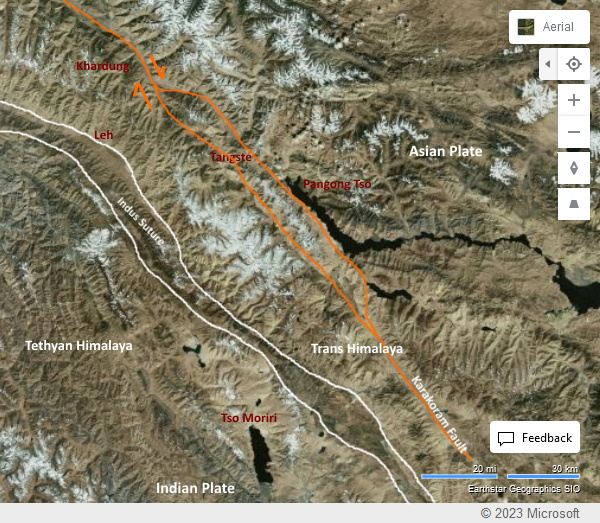
The Indus Suture is the zone of collision between the Indian and Asian tectonic plates.
It contains broken pieces of oceanic crust and deep sea sediments which were uplifted and jammed between the colliding continents.
A geologic no-man's land!
It contains broken pieces of oceanic crust and deep sea sediments which were uplifted and jammed between the colliding continents.
A geologic no-man's land!
The Tethyan Himalaya are the ranges immediately south of the Indus Suture. They are the deformed rocks of the Indian plate.
The Trans Himalaya are the ranges north of the Indus Suture made up of a variety of rocks of the Asian plate.
The Trans Himalaya are the ranges north of the Indus Suture made up of a variety of rocks of the Asian plate.
The Tethyan Himalaya are Paleozoic & Mesozoic sedimentary rocks deformed into a fold & thrust belt during (45-35 mya) India Asia collision.
Example- If your r traveling in Zanskar, Spiti, Lahaul, near about Milam and Panchachuli Glaciers, you are in the Tethyan Himalaya.
Example- If your r traveling in Zanskar, Spiti, Lahaul, near about Milam and Panchachuli Glaciers, you are in the Tethyan Himalaya.
Trans Himalaya made up of-
Granitic batholiths i.e. solidified magma formed during Cretaceous subduction (100 mya) of Indian plate under Asia. (Leh)
Metamorphic rocks & Miocene leucogranites formed during India Asia collision- 21-16 mya (Pangong Tso & Karakoram ranges).
Granitic batholiths i.e. solidified magma formed during Cretaceous subduction (100 mya) of Indian plate under Asia. (Leh)
Metamorphic rocks & Miocene leucogranites formed during India Asia collision- 21-16 mya (Pangong Tso & Karakoram ranges).
The famous and dizzying Khardungla Pass is made up of lava erupted from the same magmatic system that formed the Ladakh Batholith. It is a remnant of a late Cretaceous volcanic arc.
Important structure-
Karakoram Right Lateral Strike Slip Fault. Miocene ~18 mya. Total of ~150 km offset since then. Compressive movements along restraining bend of this fault has uplifted Pangong Ranges.
Pangong Tso is drowned river valley formed by fault uplift at W end.
Karakoram Right Lateral Strike Slip Fault. Miocene ~18 mya. Total of ~150 km offset since then. Compressive movements along restraining bend of this fault has uplifted Pangong Ranges.
Pangong Tso is drowned river valley formed by fault uplift at W end.
Short answer to question-
The Himalaya (including the Tethyan Himalaya) is the deformed northern edge of the India Plate.
The Trans Himalaya is the deformed southern edge of the Asian Plate.
end thread..
The Himalaya (including the Tethyan Himalaya) is the deformed northern edge of the India Plate.
The Trans Himalaya is the deformed southern edge of the Asian Plate.
end thread..
sorry , one more!
Recommend Mike Searle's Colliding Continents: A Geological Exploration of Himalaya,Karakoram and Tibet.
Recommend Mike Searle's Colliding Continents: A Geological Exploration of Himalaya,Karakoram and Tibet.
Loading suggestions...